
1
/
von
1
National Geographic Trails Illustrated Map Virgin Islands National Park, St. John, USVI
National Geographic Trails Illustrated Map Virgin Islands National Park, St. John, USVI
Normaler Preis
CHF 16.90
Normaler Preis
Verkaufspreis
CHF 16.90
Inkl. MwSt.
Versand wird bei Kasse berechnet
Sofort ab Lager lieferbar.
Anzahl
Verfügbarkeit für Abholungen konnte nicht geladen werden
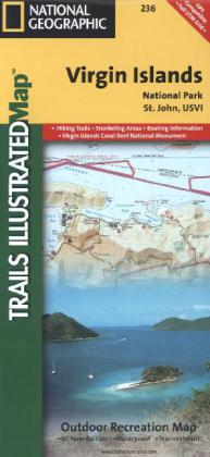
Trails Illustrated topographic maps are the most detailed and up-to-date recreation maps available for these national parks, national forests and popular outdoor recreation areas. This map includes: the island of St. John; the entire Virgin Islands National Park; Virgin Islands Coral Reef National Monument; Mount Sage National Park; Tortola Island; Great Thatch Island; Little Thatch Island; Frenchmans Cay; Lovango Cay; Congo Cay; Mingo Cay; Dog Island; Hawksnest Bay; Durloe Cays; Durloe Channel; Cinnamon Bay; Trunk Bay; Mary Point; Francis Bay; and UTM grids for GPS.
Weitere Angaben
Unbekannt (CA), Polychrome print. Folded, Englisch, 1 Seiten
Jetzt Liquidations-News abonnieren
Immer die neusten Abverkäufe und Räumungen kennen! (Max. 1 Nachricht / Monat)